Moses lived from about 1391 BCE to 1271 BCE. The Borders of Eretz Yisrael were dictated to Moses by G-d as found in Numbers 33:52 to 34:21. " The land of Canaan is to fall to you as an inheritance. The fact remains that Moses never did get to enter Canaan but certainly was able to be knowledgeable about the geography through this communication. .
The southern side shall be from the Wilderness of Zin at the side of Edom,
Your southern border shall be from the edge of the Salt Sea to the east. The border shall go around south of Maaleh-akrabbim, and shall pass toward Zin; and its outskirts shall be south of Kadesh-barnea; then it shall go out to Hazar-addar and pass to Azmon. The border shall go around from Azmon to the stream of Egypt, and its outskirts shall be toward the Sea.
The western border: It shall be for you the Great Sea and the district; this shall be for you the western border.
This shall be for you the northern border: from the Great Sea you shall turn to Mount Hor. From Mount Hor you shall turn to the approach to Harnath, and the outskirts of the border shall be toward Zedad. The border shall go forth toward Zifron and its outskirts shall be Hazar-enan;
You shall draw yourselves as the eastern border from Hazar-enan to Shefam. The border shall descend from Shefam to Riblah, east of Ain; the border shall descend and extend to the bank of the Kinnereth Sea to the east. The border shall descend to the Jordan, and its outskirts shall be the Salt Sea;
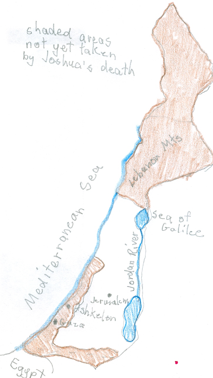
This shall be the Land for you, according to its borders all around". In the map above, the brown shaded areas were not yet taken by the time Joshua, the Israelite commander and successor of Moses, died. Moses had directed him to to lead the people in the conquest of Canaan. Judah and Samaria are included inside the borders of Israel being they are on the West side of the Jordan River; thus the incorrect name of "West Bank," given to the area by the Jordanians.
Knowing the borders of Israel became important because of the many commandments that are to be followed only inside this land. Notice that the border begins at the extreme southeast and goes from there to the west, then northward, eastward and finally, southward. to join the original starting point. The Jews could not bring themselves to eliminate all the Canaanites. The Northern shaded area with the Lebanon Mts. remained as Lebanon. King Solomon was able to get Cedar trees from there to use in the Temple through trade and friendly relations. .
Reference: Tanach, The Stone Edition; the Torah/Prophets/Writings; the 24 books of the bible by Rabbi Nosson Scherman by Mesorah Publications, ltd.

No comments:
Post a Comment